

Weather in DC today: Is more rain coming post-parade?
WASHINGTON - It may be officially the final weekend of spring here in the D.C. region but saying it is anything other than a busy summer weekend would be an understatement.
World Pride events continue across the D.C. region, the Nationals are at home taking on the Miami Marlins, the military is celebrating their 250th anniversary with a parade, and of course, Sunday just so happens to be Father’s Day.
There is a lot to get you outside this weekend, but will thunderstorms drive you back inside?

The forecast:
The setup for Saturday was a typical one for summertime in the D.C. region.
A stalled front, that is an atmospheric boundary, not moving much, was draped across our region. It is this front that will be the focal point for storms to fire over the course of the day.
Exactly where it sets up, and how it "wiggles" as the warmth and humidity of the day build, will determine who has the best shot at seeing more active storms in the afternoon.

So a key question we will tackle right away: is Saturday a washout?
No. In fact, the morning hours look relatively quiet across the region.
There will certainly be some cloud cover and morning rain and even a few thunderstorms leftover from activity Friday night are still possible to be ongoing across Pennsylvania and parts of the Maryland and West Virginia Panhandles but much of the region should start the day dry.
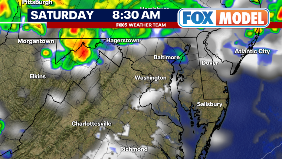
Even the lunchtime hours look relatively quiet around our region, though it is likely when we start to see the first signs of trouble appearing on radar, with terrain-driven thunderstorms firing over the mountains, slowly starting to drift eastward as the warmth and high humidity of the day are ramping up across the D.C. region.
Highs are expected to be in the low to middle 80s, but will likely feel like the low 90s with the high humidity in place.

As we approach the middle afternoon, with the Nationals game likely still ongoing -- first pitch scheduled for 1:05 p.m. – is when weather models suggest that the first storms could fire around the DC region, in the 2-4pm window.
Now, a key about the situation Saturday is it will be heavily driven by the warmth and instability of the day.
This means that if the day is cloudier, with no or very limited sunshine, storms will likely lag though the day, firing later instead of early. It will be heavily dependent on the breaks in the cloud cover and sunshine that are expected during the morning and early afternoon.
A cloudier-than-expected afternoon is not a bad thing, and it would help limit how widespread storms could be.

By the early evening, with the military parade at 6:30 p.m., most weather models suggest that we will be dodging scattered thunderstorms. It’s important to note that not everyone would see these at any given time.
If a storm happens to pass over DC at say 2 p.m. or 3 p.m., it may stabilize the air over D.C. enough that the early evening hours could be drier, before more storms could then rumble through later in the evening.
It is the definition of an unsettled day. There is not any organized storm system to track, no wall of water heading for us, just an unsettled day were one storm firing could lead to a domino effect of more storms firing through the second half of the day.

This includes the evening hours around sunset, when humidity naturally rises as air temperatures cool, keeping the threat for storms alive even after sunset.
So do not let your guard down just because the sun goes down. In this type of a situation, the sunset hours and just beyond can often be when storms are most widespread across the D.C. region.
We know fireworks are planned to wrap up festivities on the National Mall downtown, but Mother Nature may be proving her very own around that time.

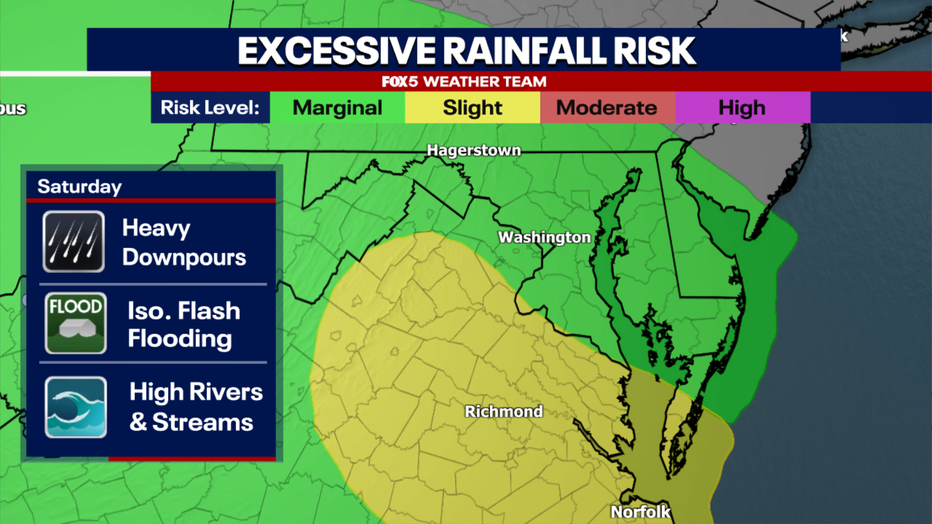
Flood Watches have been issued in anticipation of this threat. While at the moment they mostly cover areas from D.C. and south, we would not be surprised at all to see these expanded heading into the day on Saturday. We will keep you up to date through the weekend as watches and warnings get issued.
What's next:
Father’s Day Sunday is the one day this weekend that has been undergoing some changes in the weather modeling, though not necessarily for the better.

Latest trends have been trying to sneak in a wave of high pressure off the New England coastline, pushing the stalled boundary a little farther southward for the day on Sunday, so it’s centered closer to the North Carolina-Virginia border.
Unfortunately, it also comes with an eastern wind for most of the day, leading to thicker cloud cover, cooler temperatures, and the threat for more drizzle and showers.

Later in the day, some sun poking through west of town could destabilize things enough that some heavier showers and storms fire, though this is most likely closer to the frontal zone farther south and west of the immediate DC area.
However, for any planning some outdoor BBQs or pool days for dad, Sunday may not end up being the best outdoor days. Latest trends for D.C. and areas north suggest that some may not make it out of the 60s on Sunday afternoon.
Stay tuned:
With the unsettled forecast and so many activities planned for this weekend, the FOX 5 Weather Team will continue to be here and update on any updated forecast and weather conditions throughout the duration of it.
Stay tuned to the free FOX Local app as well as keep you up to date on all things D.C. weather!